
How does a GPS work, anyway?
Dec 082015We kind of get used to some pretty amazing technologies. For instance, GPS (or Global Positioning System) has only been available to consumers for a little over 10 years. Yet, most of us have already become pretty dependent on our GPS enabled devices. It is rare to drive in a car without a GPS device and almost every smartphone will be enabled. (And some of us use these devices to enjoy geocaching as we've talked about before). But how many people understand how they work? We're going to explain that to you... simply (because that's about our level of understanding).
Let's start with satellites. There are about thirty or so satellites continually circling the earth at about 30,000 kms (12,000 miles). These are solar-powered satellites each about the weight of a mid-sized car. These satellites are always sending encoded signals in every direction. The orbits of the satellites are designed so that at least 4 and usually more, are in line of sight to every point on earth at all times. It actually takes about 24 satellites to provide this coverage - but the extras are there in case replacements are needed. The signals can go through clouds and glass and gasses - but not through solids... so you will not be able go get a location fix when you're underground - or under a deep tree canopy in a forest.
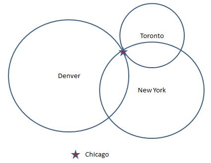
Now back on earth, these satellite signals are received with your GPS device. Essentially, your device will decode the signal, figure out how long ago it was sent and from that information it can compute it's distance from the satellite. So, how does your distance from a faraway satellite help locate you? It happens though a process called 'trilateration'. Big word, but fairly simple idea. Imagine you were situated somewhere in the middle of the USA. And you had a big map in front of you. Imagine you were given 3 figures, each a distance from a fixed location. For example, New York - 713 miles; Denver - 913 miles; and Toronto - 437 miles. With this information you could use the map scale to draw three big circles from each of the fixed locations. And the three circles would intersect in only one place - Chicago.
So that's fine for fixed locations on earth - but satellites? It turns out to be only a little more complicated in that case. Because satellites are in space, when you have the distance, you have to think about the possible locations as being on the edge of a sphere instead of the circle we drew on the map. And your location would be the intersection of the spheres from each of the 4 satellites your device was using.
The rest of the story is simply software. Your GPS device will calculate the location as a pair of co-ordinates. One is latitude (your north/south position) and the other longtitude (your east/west position). For instance, Chicago is roughly 41° 46' 0" latitide and -87° 37' 20" longtitude. Then, your device will usually overlay this coordinate on a map that it has in its memory. All that to tell you how to find the way to Aunt Sally's new house!