Aug 092019What's the opposite of clicking on a map to show where a country is? We'll show you the country on the map, and you type in its name.
This reverse activity will keep your brain fresh - you'll have to think in a different direction, plus you'll have to learn how to spell. It's funny the things you think you can spell until you actually have to do it!
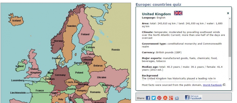
Here's what it looks like:
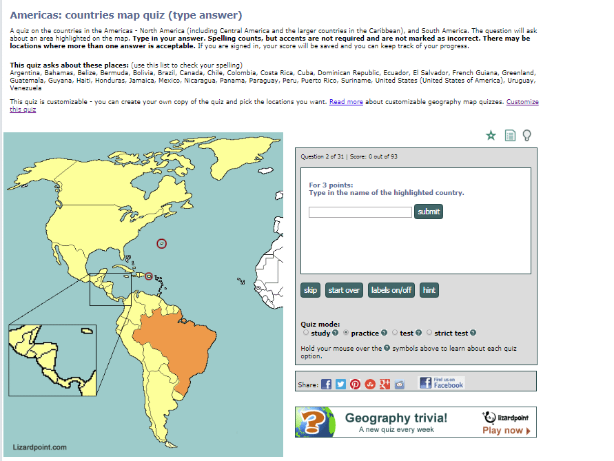
Spelling counts. We can't check every possible name for a country, so for the most part, we are using the common short names used in English.
If you're in doubt as to what we'll accept for the answer, check the section near the top of the screen where it says: "This quiz asks about these places", followed by the list of names, in alphabetic order. This list to help you with your spelling will only be available in practice mode. In other test and strict test modes, you'll need to remember how to spell.
If we accept an alternative, it will be in parentheses - for example "Côte d'Ivoire (Ivory Coast)". Good news - you don't have to type the accents. If you choose to use accents, we ignore them, so a correct answer doesn't necessarily mean you got the accents correct.
Another thing you can do in practice mode is get a HINT. Just click on the Hint button to see the first letter of the country name... keep clicking to reveal more letters. For now, you can ask for as many hints as you need.
Where to find these quizzes:
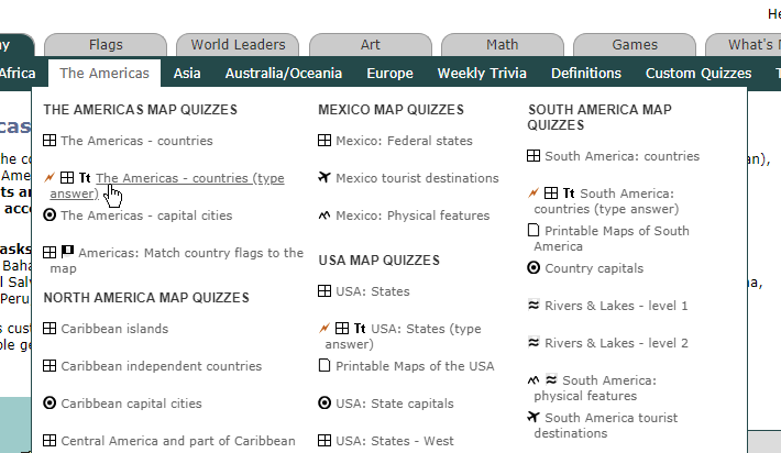
We've just launched 9 of these quizzes. Look for the Tt symbol on the menu:
Here are the direct links to them:
Also, all of these quizzes are customizable, meaning you can choose which questions to test yourself or your students on. Some are customizable by anyone with a free account, and some are customizable by premium members only.
Happy learning!
Lyndsey
Aug 162018We've just launched a handful of new quizzes designed for Travel and Tourism students, but anyone can use them. The questions cover a variety of types of destinations: cities, popular sites, landmarks, national parks, resorts, beaches, natural wonders etc. Check the end of this post for a sample customization of a USA quiz that is more geography focused.
These quizzes require you to know the country, state or province where a destination is located. So, for example, in the USA tourism quiz, if you are asked "Where is the Empire State Building?", you would answer by clicking on the state of New York.
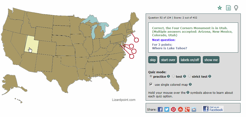
The tourism quizzes offer a feature we've never offered before - a destination can be in more than one place. So if we ask you where the Four Corners Monument is, Arizona, New Mexico, Colorado and Utah are all acceptable answers. And we'll show you that in 2 ways:
1. When you click on the "show me" button, all acceptable answers are highlighted, as the following screen capture shows:
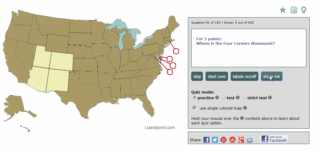
2. When you click on a correct answer, the answer response lists all the acceptable answers, as shown in the following screen capture. The user answered with Utah, and the response from the quiz was, "Correct, the Four Corners Monument is in Utah. (Multiple answers accepted: Arizona, New Mexico, Colorado, Utah)"
So far, we've created tourist quizzes for Africa, the Middle East, Canada, the USA, the Caribbean, Central America and South America. Quizzes for Europe, Asia and Australia/Oceania will be coming soon. Look for the airplane icon in the navigation to easily spot these new quizzes. You can see 4 tourist quizzes in this screenshot from the Americas navigation:
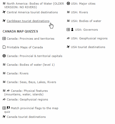
sample navigation with airplane icons indicating the tourist quizzes
The destinations asked in the quizzes were based on the learning needs of a particular tourism program at a Canadian college. But all the tourist quizzes are customizable, so that you can select from just the destinations you need. If you are an instructor of a Travel and Tourism program and you'd like some destinations added to the quizzes, please send us an email. Eventually, we hope to make it easy to add destinations yourself, but in order to satisfy an immediate need, we had to launch the quizzes with a fixed set of questions.
We realize that Travel and Tourism students need to know a lot more than just where the destinations are, but these quizzes will help with the "where", and free your mind up to learn the rest of the details you need to know for your program.
And now, for the example I mentioned earlier - here's a customization of the USA tourist quiz on mountains, caves and natural wonders. It's just a quick 11 question quiz but it serves as an example of how you can create a geography quiz that isn't necessarily tourism related.
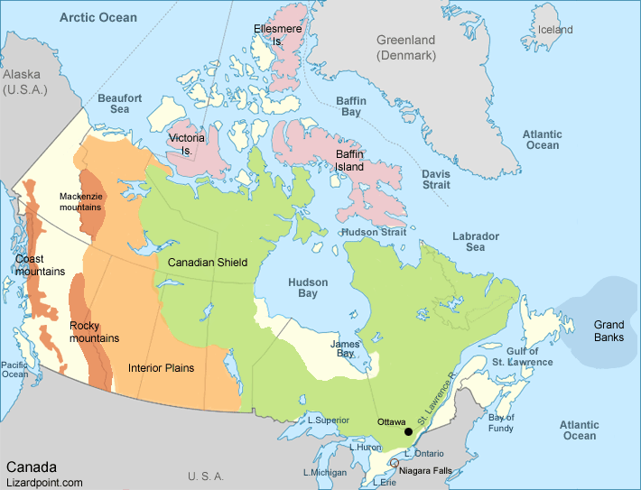
Jan 222018A new quiz on Canada was just launched: Canada: physical features. It covers an assortment of bodies of water, mountains, arctic islands, and landforms. It's also customizable, if you have a premium account.
This labeled map shows what's on the basic Canada: physical features quiz.
Feb 252017New Quizzes added in February 2017. More quizzes will follow in a couple of weeks...
- North America bodies of water: there are 16 questions in this quiz, and it's customizable for premium members.
- Canada Seas, Lakes, Bays, Rivers: we've combined the smaller Bodies of Water, and Rivers quizzes to make one bigger quiz with 37 questions. And it's customizable for all account holders.
- Spain autonomies quiz: the first level administrative divisions are called autonomous communities. 19 questions.
New customizations available:
Jan 112016While everyone else this morning is reeling over the death of David Bowie, I'm far more shocked at the news that Canada has just been cut in half!
Living in a metropolitan area of over 6 million people, I often forget just how remote and isolated much of Canada is. And I never imagined that one bridge in the middle of Canada was the only thing joining the west with the east.
Due to extreme weather conditions, the Nipigon River Bridge has failed, causing one side of it to rise two feet. This bridge is on the Trans-Canada Highway, which you may gather from the name, is a highway that goes pretty much right across Canada.
“Canada has been cut in half,” said Nipigon Mayor Richard Harvey. “If you want to take something from Toronto to B.C., it goes across this bridge. There is no alternative. Every truck that goes across Canada goes across this bridge.” (Quote from the Toronto Star article on the bridge closure.)
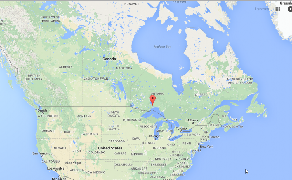
Location of the bridge failure in Nipigon, Ontario. (Image credit: Google maps)
Zooming in, you can see the Trans-Canada Highway is pretty much the only road around. Other minor roads shown in grey just service local communities.
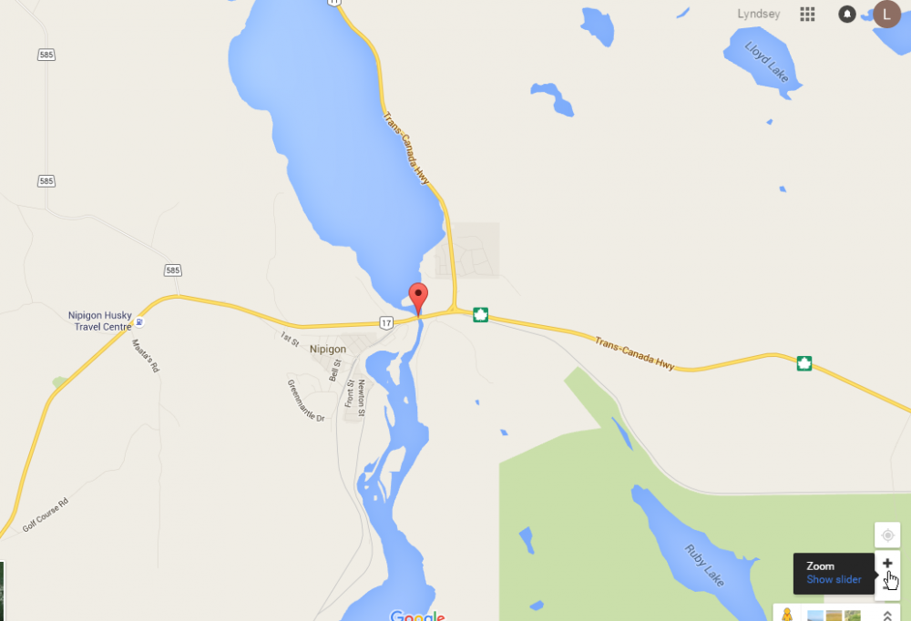
Detailed map of Nipigon River Bridge location, showing Trans-Canada Highway. (Image credit: Google maps)
While the bridge is closed for who knows how long, all trans-Canada traffic must now take a detour through the US.
Gotta love Google, they're on top of things, already showing that the bridge is closed, and what the detour is. It looks like the additional travel time is 4.5 hours, plus however long the border crossings will take.
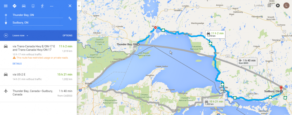
Detailed map of Nipigon River Bridge location, showing Trans-Canada Highway. (Image credit: Google maps)
This is a matter of national security, and will cause some serious economic impact, and I imagine will be the source of a lot of jokes. The perfect storm of Canada's renowned cold weather and remoteness.
Sep 302015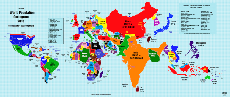 Map by Reddit user TeaDranks
One of the things that interest us at Lizard Point are visualizations that provide a different perspective on the world we inhabit. Maps are especially good at this. And not all maps have to be physical (showing geographic features) or political (showing state boundaries). The map above, recently featured in the Washington Post, is a World Population Cartogram. According to Wikipedia, A cartogram is a map in which some thematic mapping variable – such as travel time, population, or Gross National Product – is substituted for land area or distance. The geometry or space of the map is distorted in order to convey the information of this alternate variable. I think you would agree that the perspectives provided by this map are quite different that the maps we usually see.
Any insights you get from the map depend on your own perspective. For instance, we at Lizard Point live in Canada, a huge country in terms of land mass. But as the cartogram illustrates, a very small country when it comes to population. Even our neighbours to the south in the populous United States, shrink a little when compared to the populations of India and China. A few other surprising insights that we found;
- the relatively small size of Russia (less populous than Nigeria),
- the large size of some of the Caribbean countries (Cuba, Haiti, Dominican Republic), and
- the complete absence of large countries such as Greenland and Iceland.
No doubts, you'll have some insights of your own. We encourage you to visit this and other interesting maps from the Washington Post website embedded in a fascinating article by Ana Swanson entitled, The best places to be alone all over the world.
And don't forget that Lizard Point quizzes has population (and much more) information about all the countries in our site. Just click on the 'study' button.