A frequently requested site feature is the availability of blank maps (and answer keys) for teachers and students to print and fill in manually. Not everyone learns the same way, so the printed blank maps will give you another way to practice your geography.
Blank outline map: A basic map with just the outlines of the countries (or regions/states/provinces). Students can write the names on the map.
Labeled outline map: The basic outline map with the answers placed on the map. This map can be used to study from, or to check the answers on a completed outline map
Numbered outline map: The basic outline map with every location numbered. Beside or below the map is an area to write the place names associated with each number.
Numbered labeled outline map: The numbered outline map with the answers beside the numbers. This map can be used to study from, or to check the answers on a completed outline map.
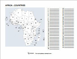
Here's a sample numbered map of Africa with slots to fill in your answers. Click on the image to download and print the PDF file.
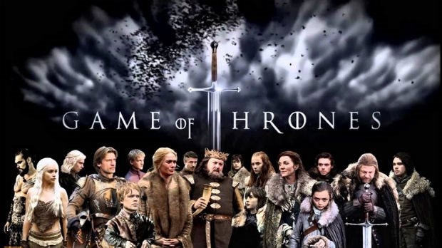
Time to 'fess up. We're huge GoT fans here at Lizard Point Quizzes. So you know a quiz with 'geography and Game of Thrones' in the title is bound to capture our attention. Here's a link to "How well do you know your Game of Thrones geography".
Game of Thrones Cast Banner/Credit: HBO
Fair warning - you won't beat my score! But then, I have read all the books and seen all the epidsodes... good luck.
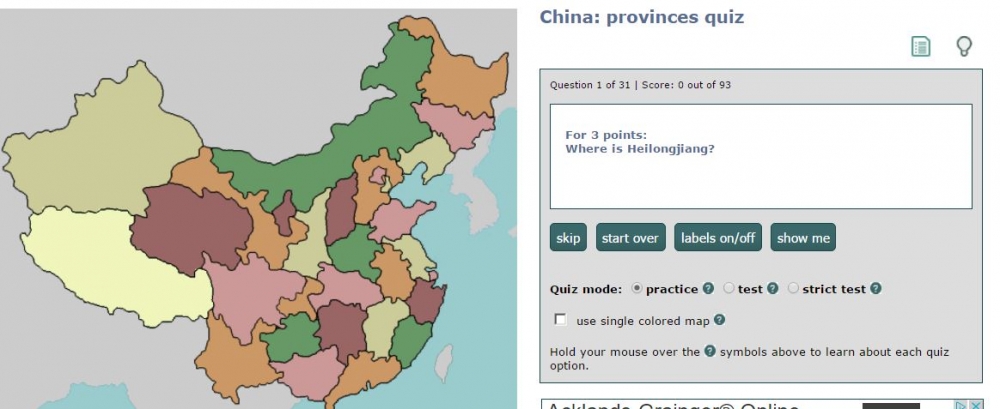
Remind me to be very, very careful on my next (well, ...first) visit to China. As you know, Lizard Point is in the business of using maps to help people learn more about the world they live in, and in China - that can prove to be a risky proposition.
According to this article on ozy.com, China has a law against any illegal map that “endangers the country’s sovereignty, safety and interests”. And if your map doesn't comply with the country's rules - you can be in for a fine of up to 200,000 yuan (about $30,000 USD). The rules include naming the South China Sea properly and marking Taiwan, Hong Kong and Macau in the same colour as mainland China.
Er, excuse me while I go double check our quizzes.
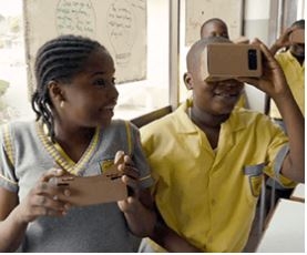
The folks at Google are piloting an interesting immersive geography program that might interest some of our readers.
The gist of the program is a to take students on a kind of virtual expedition where they can experience more than 100 interesting journeys. These simulated journeys could include a visit to the South Pole, coral reefs or ancient American ruins. With the Expedition Kit, students will be able to look up and down, and spin to get a 360-degree view of a location, as if they were visiting in person.
Expeditions teams will visit selected schools around the world, including the United States, Australia, New Zealand, the United Kingdom, Brazil, Canada, Singapore and Denmark. Each team will bring a complete Expeditions kit with everything the teachers need to take their students on journeys anywhere. The team will show teachers how Expeditions works and help set it up before class.
There is no charge or cost involved in the program. You just need 6 interested teachers.
Visit Googles page to sign up to let them know you’d like the Expeditions Pioneer Program to stop at your school. Or read about another school's experience with the program.
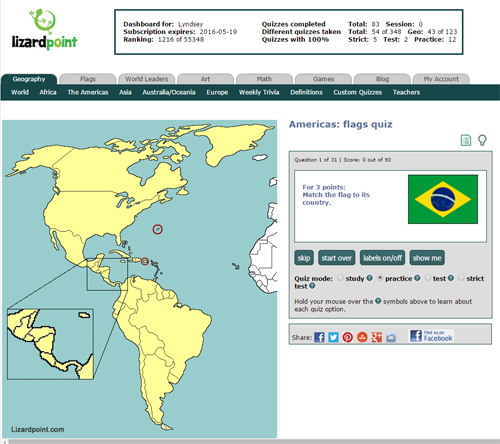
We've just launched two new quizzes to test your country flag knowledge. We'll show you a flag, you have to find the country on the map. The Africa and Europe versions have been around a long time: now we've got an Americas flag quiz as well as an Asia flag quiz.
As promised, our supporters get early access to new quizzes and features. For everyone else, the new quizzes will open up to you on February 1, 2016.
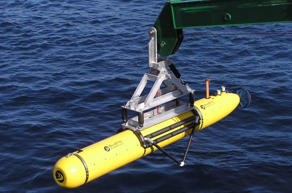
Drones are much in the news these days as prices fall and make the technology more and more accessible. Most of the interest is in the flying types of drones, but a recent GEOGRAPHICAL item discusses a different type of drone that has the potential to make new geographical knowledge available. As part of a growing interest in underwater drones, a start-up company called Hydroswarm is developing a robot to map the seafloor in greater detail.
Bluefin-21, the underwater drone of US navy sent to locate the debris of missing Malaysian plane MH370,
The EVE robot is a pumpkin-shaped bot is made for searching the sea. Made up of one part steering mechanism and one part ultrasound sensor, the autonomous drone could be more useful than existing remotely-operated robots as ‘they are less complex, but smart in terms of sensing,’ according to Sampriti Bhattacharyya, mechanical engineer at Massachusetts Institute of Technology and EVE’s creator.
Still in its development stage, the drone can only dive 250 metres below the surface. However, Bhattacharyya has ambitions towards using this kind of technology to create a deeper ‘Google Maps’ of the sea. ‘The whole point of Hydroswarm is to provide a cheap and scalable method of mapping the ocean,’ she says. ‘EVE can be used as a single drone, or as a bunch of them working together to map large areas.’ Deployed en masse, the drones use algorithms to communicate with each other in a network. Plus, they don’t get lost. ‘They have a homing mechanism and are recovered at the end of their missions,’ she says.
Beyond Hydroswarm - hobbyists can examine other startups with their own versions of underwater drones. Fathom and OpenROV both have interesting technologies and approaches.
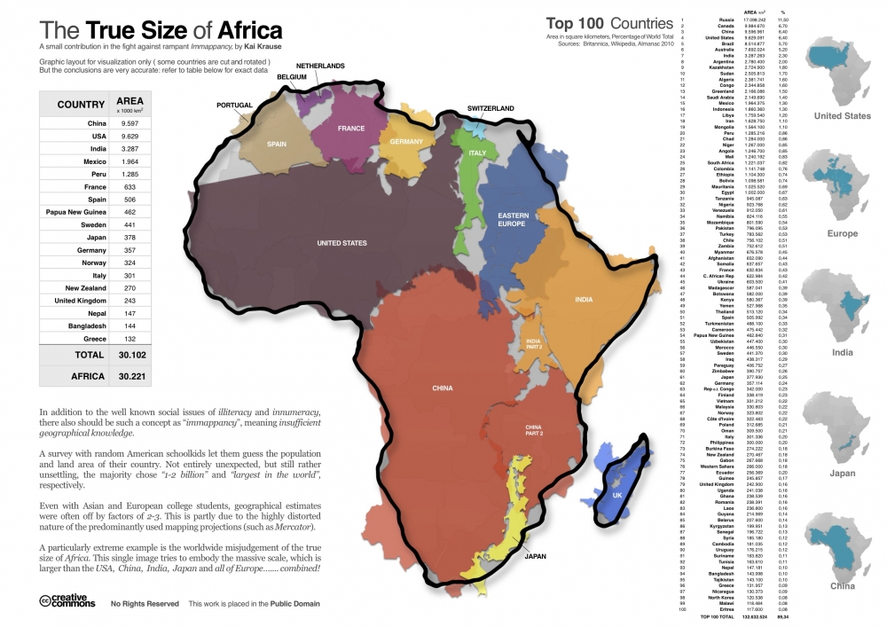
Another brilliant graphic that illustrates the true size of Africa (click on the map to see the full sized version).
This graphic very visually demonstrates that Africa alone is larger (in terms of area) than China, USA, India, Mexico, and much of Europe and South America. The power of this graphic and the surprise that it creates for readers, is based on the deep impressions made by the Mercator projection used in most maps that distorts the true size of many countries. This projection, published in 1569, was immediately useful because it depicts a line of constant bearing as a straight line, which is handy for marine navigation. The drawback is that it distorts the shapes and areas of large land masses, and the distortion gets progressively worse as you get closer to the poles.
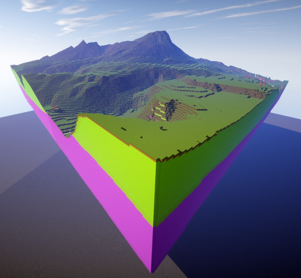
Anytime there's a new 'thing' combining geography and geeky - you know someone at Lizard Point is going to be on it. UK's Geographical site just published a piece describing how the British Geological Service (BGS) has recently completed a rendering of Great Britain done entirely in MicroSoft's wildly popular Minecraft world.
Minecraft is one of the most popular videogames in the world, especially among children. It's in a class of games called massively multiplayer online games (MMO). These games place the player in immersive environments where they can interact with other players and explore their environment. Minecraft is particularly interesting as it gives the players the ability to actually create and shape the worlds that they are exploring.
It would be incredibly interesting to simply explore existing surface geography in the Minecraft world, but the BGS has taken it another step further, or deeper. Steven Richardson, the geospatial applications developer at the BGS, says ‘we added the geological data too so that when players are looking at this map, they’re not just seeing where the M1 goes upcountry, they can dig down into the blocks and see what the geology is. It adds a third dimension to this data’.
It isn't hard to imagine the educational possibilities that this presents geographers. Instead of lecturing alone, or poring over maps - Minecraft would actually provide students a way to immersively experience the world and (in this case) see the geological layers under their feet.
This year the National Geographic Society marks the 100th anniversary of their cartographic department. And Geography Awareness week seemed a good time to celebrate this milestone. The magazine's current issue features stories on some of the more interesting maps produced over the last century.
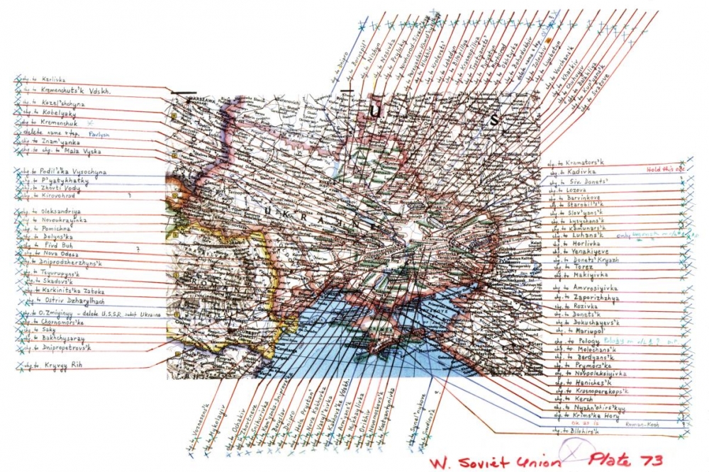
In reviewing it, you just can't help but be impressed with the breadth of maps and the unbelievable detail needed to render accurate, timely documents. One illustration shows some of the work necessary after the dissolution of the Soviet Union in 1991. This event necessitated changes to 90% of the place names in the Ukraine alone. I was certaintly struck by how manual this whole process looked. (At Lizard Point we are well aware of the detailed work involved in adjusting maps - but at least we do it all with programs and databases). In the case of the Ukraine, the illustration below shows printing and pointers overlaid on an analog map plate.
With a century of history to draw on, the National Geographic also has many rich memories. They feature the map that General Dwight D. Eisenhower carred across Germany during the Allied offensive in 1945. They also mention the story of Admiral Chester Nimitz landing lost in a rainstorm, utilizing the Society's map of the Pacific war theatre.
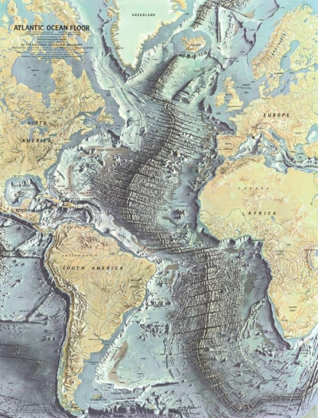
One featured map from 1968 really caught our attention. It charts the map of the floor of the Atlantic Ocean based on work of early geophysicists. Besides the beauty of the art work, what really stands out is the degree of detailed elevation in a part of the world that we are used to seeing as a uniform, flat, pale blue. This map brings home the reality of plate tectonics in a way that thousands of words could never convey.
The article closes with some words on the future of cartography with some tantalizing comments on the role of 'crowdsourced' cartography and the use of wearable technologies to increase the capture of geo-data. We can't wait.
Sigh... I thought I was doing all right with knowing about 65% of African countries... but little Max here seems to have me out-paced by some margin. The video was originally posted to the Tony Kroukamp YouTube Channel and shows 3-year-old Max rattling off names to countries while his father points them out on the map.
Now we just have to get Max onto Lizard Point and let him loose on the rest of the world. (Here`s a link to Lizard Point`s Africa quiz to test yourself against Max.... )
Well, we really don't know that... but he sure does love making fun of Americans being bad at Geography. And we believe our job is to, you know... fix that. As Laura Bradley points out in her recent piece on Slate, Oliver would be "...the teacher from hell. Is the highlighted country on the map actually the country he’s talking about, or will it turn out to be on another side of the continent entirely?"
Anyway, it's a fun little clip. Click it for a chuckle or two.
(You knew where Uruguay was immediately, right? If not, do we have a quiz for you!)
Since we started Lizard Point Quizzes, teachers have continually requested the ability to customize quizzes of their own to match their lesson plans. And we know some learners would prefer to focus on those few countries in a map that are giving them difficulty. So, voila....