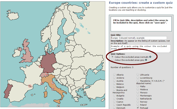
When we implemented custom quizzes a few months back, all custom quizzes had the same behavior: if a country, France for example, isn't included in the customized version of the Europe quiz, it is coloured differently (a very light white-grey) to make it plainly obvious that it is not in the quiz. And if you click on it, the response is "France is not included in this quiz. No points lost. Try again", and you still have the same number of tries left - that is, it does NOT count as a guess.
This set-up works out quite well when you're trying to learn a smaller chunk of what might otherwise be an overwhelming quiz: it lets you focus on just what you need to learn.
But when it comes to test time, your teacher probably isn't going to cross out the countries you don't need to know. So we're now offering a choice of 2 options when you set up your custom quizzes:
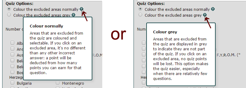
colour the excluded areas normally (and scoring penalty for any wrong answer)
colour the excluded areas grey (and guesses to excluded areas do not count as a guess)
I've set up 2 sample quizzes so you can see the difference. Each quiz has the exact same set of 5 questions: United Kingdom, Germany, Switzerland, Italy and Portugal. One quiz has the all the excluded areas coloured normally, and the other quiz has excluded areas coloured grey. Go ahead and try them out and see the difference... click on France to see the difference. (If you're not sure where France is, use the labels on button and look for France).
When you create a custom quiz, the way you select which option you want is just above the list of places you can choose, as shown in this screenshot:
When you are selecting your countries to include in your custom quiz, you will not see the difference on the map - you won't see the effect of it until you save the quiz.
If you don't like the option you chose, you can always, at any time, edit your quiz and switch options.
Need a reminder of what the options mean? Hold your mouse over the question mark icons (or tap on your touch screen) to see the explanation:
We just got a nice email from a trivia fan telling us how much he and his kids enjoyed the quizzes. It reminded me that I'd been meaning to do a blog post on the making of the quizzes.
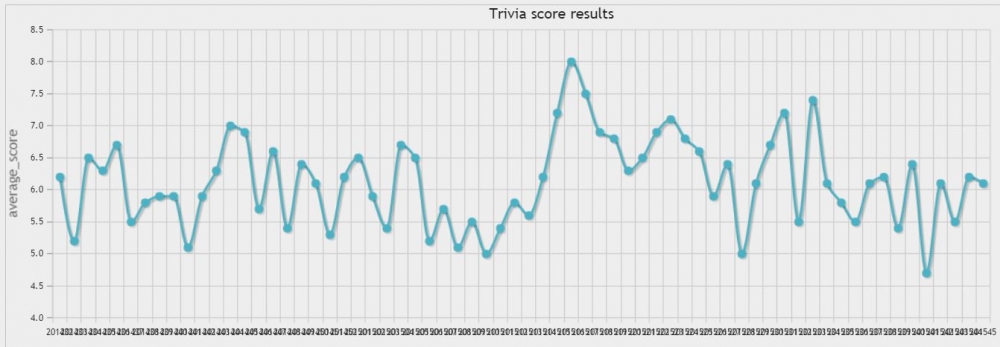
We started publishing them last summer, and we now have about 66 available. Our overall average score comes in at around 60% (remember, though, that we only record completed quizzes - and I have a feeling that some of the really tough ones don't get completed). You can see from the chart below that our all-time high average score was 80%. That was on April 19th, 2015. Pretty well every question on that quiz was answered smartly. The toughest ones score an average of about 45%.
The question that you all found the easiest (97%) was identifying the pictured G20 leader on Jan 25th, 2015 (but then, he is a fairly well known politician). And the toughest (23%) was this: Which of the following cities is most populous (metro population)? Seoul, Mumbai, Calcutta, Mexico City. That question was asked on November 16th, 2014.
By the way, we always state the average score on the quiz after you complete it, so you can compare your score to other Lizard Point quiz-takers. The quizzes are published at midnight EST on Sunday mornings. Real early birds won't see the average score since we collect a few hundred before publishing the average.
We try to make the questions engaging - and we do take any feedback we get to heart. So you'll see we've reduced some of the unpopular questions (like distances between cities). We try to focus on geography - but you will also see a sprinkling of questions on astronomy, geology, history, climate etc... We'd love to hear more from you about types of questions you'd like to see (comment, comment).
I've got a tip for you that will make it really easy to learn the location of the countries that end with "stan"!
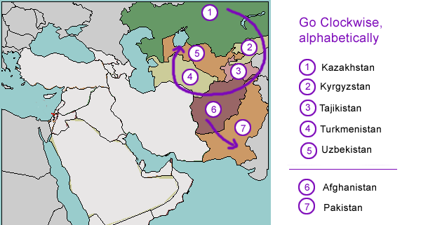
There are seven countries in Central Asia that end in "stan". Thankfully, Pakistan and Afghanistan have been around for a lot longer, so for those of us who grew up and learned our geography back when the U.S.S.R. existed, we really only have to learn 5 of them.
For starters, the other five "stans", in alphabetical order, are:
Kazakhstan
Kyrgyzstan
Tajikistan
Turkmenistan
Uzbekistan
Notice that there are two K's, two T's, and a U. We're simply going to put them on the map clockwise from the top, starting with Kazakhstan and ending with Uzbekistan:
Simple, right? And Afghanistan and Pakistan are right underneath, in alphabetical order, from the top down.
(By the way, the suffix 'stan' comes from the Persian root, istan, meaning land.)
WARNING: The next part, the capital cities, gets a little crazy. You may not even want to try to get through this - but if you've got a test coming up, and you really need to memorize this, it might help.
Ready for the capital cities? They aren't quite as easy to create a tip for, but here's my best shot...
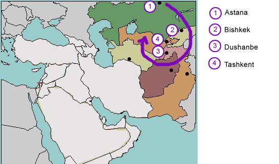
First, let's review the capitals:
Astana, Kazakhstan
Bishkek, Kyrgyzstan
Dushanbe, Tajikistan (did you notice, so far we're still in alphabetical order?)
Ashgabat, Turkmenistan (uh-oh, another one starting with 'A'!)
Tashkent, Uzbekistan
Kabul, Afghanistan
Islamabad, Pakistan
For the capitals, we're going do the clockwise circle thing again, but we'll drop Ashgabat, Turkmenistan out of the list, and do it later, along with Afghanistan and Pakistan.
What we're left with is basically still alphabetical order, clockwise, starting with Kazakhstan, as before, but this time we'll leave out Turkmenistan, which was the most southern country in our previous clockwise loop:
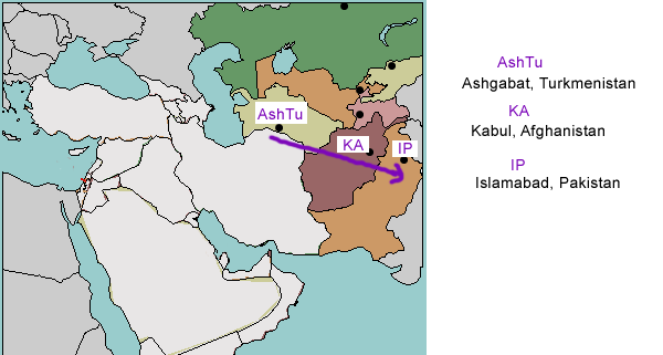
For the last 3, we have:
Kabul, Afghanistan
Islamabad, Pakistan
Ashgabat, Turkmenistan
Nothing's in alphabetical order (my favourite go-to memory tip), so we're going to use first letters to make something we can pronounce: AshTu-KA-IP. That stands for Ashgabat, Turkmenistan - Kabul, Afghanistan - Islamabad, Pakistan. And it's going on the map from top left towards bottom right:
Since we started Lizard Point Quizzes, teachers have continually requested the ability to customize quizzes of their own to match their lesson plans. And we know some learners would prefer to focus on those few countries in a map that are giving them difficulty. So, voila....